training
As part of its 2017 information, outreach and training activities around OpenStreetMap (OSM), Free GIS and opendata tools, methodes and practices in Haiti and Africa, the Organisation Internationale de la Francophonie (OIF/DFEN) supports the capacity building program that the association Projet Espace OSM Francophone (ProjetEOF) will implement in coordination with OSM membres active in these territories within informal collectives or associations.
Throughout this project, 30 ProjetEOF and OSM Project folks will work with 150 individuals from the fields of Geomatics, Free software and Opendata, ICT and community-based development within Civil Society, Private Sector and Academics in Haiti, Sénégal, Mali, Niger, Burkina Faso, Côte d’Ivoire, Togo and Bénin.
Throughout October 2107, in the capitals and main regional cities of these countries, the below-activities will be carried out:
- 15 five days workshops about information, outreach and training on data, tools, methodes and practices in OpenStreetMap, Free Geomatics and opendata ;
- 15 one day mapathons (geographical opendata creation within OpenStreetMap) ;
- 21 one day workshops which will mix conferences, technical workshops and mapathons.
These capacity building activities will be implemented by around 30 folks from the association Projet EOF and the OSM project to strengthen the skills of at least 150 OSM mappers also active in the fields of Geomatics, Free software and Opendata, ICT and community-based development within Civil Society, Private Sector and Academics.
Trainings will use domain teaching and learning materials produced with the support of OIF/DFEN and will encompass the below technical aspects that are needed to carry out OSM, Free Geomatics and Opendata activities in South Francophone countries :
- Using OSM and OpenData in Geomatics and cartography wtih Free software and web resources;
- Using OSM cartographic techniques to design and implement remote mapping programs using satellite imagery, georeferenced raster data (OSM « Field Papers » included), Francophone and global OSM community support, GPS data;
- Introduction, démonstration and training on using OSM and OpenData for webmapping with the web service uMap;
- Introduction, démonstration and training on using OSM and OpenData for Geomatics with the Free GIS software QGIS.
Mapathons will target areas of interest for local OSM collectives and their partners from Academics, FreeSoftware and Opendata movements, Government, NGO and INGOs as well a Civil Society.
One day workshops mixing conferences, technical hands on sessions and mapathons will reach out beyond usual OSM circles and therefore help to more widely sensitize, educate and advocate for OSM, Free Geomatics and OpenData.
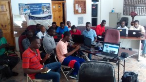
Below pictures from past OpenStreetMap, Free GIS and opendata activities in Haiti and Western Africa
- Training Fiedl data collection
- Field data collection practices in #Benin
- OSM data creation
- OSM Map
- OSM, Free GIS & opendata Training in Haiti
- Western African State Of the Map Conference (SoTM) – #Burkina
- Western African State Of the Map Conference (SoTM) – #Benin
- Community meals
- Haiti community maps powered by OSM
- Mapathon in #Togo
- #Ebola #CarCrisis Mapathon – Ivory Coast
- OSM, FreeGIS & opendata Trainings in Ivory Coast
It’s expected that this OSM, Free GIS and OpenData animation program worked out by experienced OSM folks members or collaborators of the Association Projet EOF tailored to technical and organizational needs of South Francophone countries and designed for au audience of OSM, Free GIS and OpenData newbies will result into more continued and regular activities (information, outreach, data creation, trainings) in the capitals and regional towns of the countries targeted by this OIF-Projet EOF project.
It’s equaly expected that the way these activities will be conducted will translate directly into improved capacities of newbies, an enlargement of the local OSM community as well as an increased number of OSM partners in these countries.
It’s finally expected that via the responsibilities they will have to fulfill and the experience they will gain throughout the course of this project, association Projet EOF members, collaborators and partners will build up their skills around the technical and organizational aspects required for the design, implementation and reporting of such programmes.
Follow #ActionOifProjetEOF #OpenStreetMap #Libre #OpenData in Haiti and Western Africa throughout October 2017.
We will communicate on this OIF – Projet EOF programme on the OSM lists, blogs et social media in use by Projet EOF (@ProjetEOF) and other local OSM collectives or associations in Africa and Haiti that are part of this initiative to further build the OpenStreetMap space in South Francophone countries.


