Nicolas Chavent
As part of its 2017 information, outreach and training activities around OpenStreetMap (OSM), Free GIS and opendata tools, methods and practices in Haiti and Africa, the Organisation Internationale de la Francophonie (OIF/DFEN) supports the capacity building program that the association Projet Espace OSM Francophone (Projet EOF) will implement in coordination with OSM members active in these territories within informal collectives or associations.
Throughout this project, 30 Projet EOF and OSM Project folks will work with 150 individuals from the fields of Geomatics, Free software and Opendata, ICT and community-based development within Civil Society, Private Sector and Academics in Haiti, Senegal, Mali, Niger, Burkina Faso, Ivory Coast, Togo and Benin.The #ActionOifProjetEOF « OpenStreetMap, Free GIS and OpenData » animation and training operational framework (blog post) implementation got full speed in Western Africa over October 2017 week (16-oct post, 23-oct post ) with 17 workshops of six days each and 19 one day actions lead by over 30 members of association Projet EOF for over 150 participants.
Here’s a new update about work carried out under the #ActionOifProjetEOF operational framework as of 6-November in Senegal, Mali, Niger, Burkina, Ivory Coast, Togo, Benin and Haiti.
A look back at #ActionOifProjetEOF during the last two weeks (23 and 30 October 2017) and its 7 six days workshops and 15 one day actions
Since 23-October 2017, over 30 members of Association Projet EOF members have been working with over 100 participants, running and leading 7 workshops in Niamey (Niger), Ouagadougou (Burkina-Faso), Saint-Louis (Senegal), Lomé (Togo) as well as Saint-Marc, Cap-Haïtien and Port-au-Prince (Haïti).
Together they went through 5 days training in OpenStreetMap mapping, Free GIS and opendata. They grasped tools, techniques and learning/teaching resources set up for those workshops. As a result they can create geospatial opendata with OpenStreetMap which meet their needs, they can use OSM and other geographical opendata (such as the HDX platform) with free software fit for thier needs and operational contexts like the webmapping service uMap or the GIS and cartography software QGIS.
Like during the first two week of #ActionOIfProjetEOF (since 9-October 2017), these five days of collective learning lead to organizing a one day mapathon (a workshop focused on data creation with OSM) targeted to priority areas of interest (AOIs) for the OSM project in these territories. This collective ability to apply technical and community know how acquired during the training is promising for future reuse, replication of activities conducted within the #ActionOifProjetEOF operational framework and thus its impact.
Parallel to these six days « OSM, OpenData and Free GIS » camps, the association Projet EOF members held 15 one day actions mixing conferences, technical sessions and mapathon to reach audiences beyond the participants of the one week actions.
-

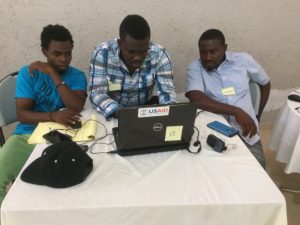
- OSM talks in Port-au-Prince (Haiti)
-

- Training on field survey with OpenStreetMap in Cap Haitien (Haiti)
-

- OpenStreetMap field work in Saint-Marc (Haiti)
-

- OpenStreetMap field work in Saint-Marc (Haiti)
-
- Editing the OpenStreetMap database in Saint-Marc (Haiti)
-

- Editing the OpenStreetMap database with JOSM
-

- Using OpenStreetMap data with QGIS in Lomé (Togo)
-

- Using OpenStreetMap data with QGIS in Saint-Louis (Sénégal)
-

- Mapathon in Lomé (Togo) bulk data creation in OpenStreetMap
-

- Mapathon in Ouagadougou (Burkina) bulk data creation in OpenStreetMap
-

- Haitian « visuals » for one of the 7 Mapathons held in Haiti and Western Africa on 28-Oct
-

- Senegalese participants of one of the 7 Mapathons held in Haiti and Western Africa on 28-Oct
-

- Participants of a one day « OSM Free GIS and opendata » action in Niamey (Niger)
-

- Participants of a one day « OSM Free GIS and opendata » action in Lomé (Togo)
-

- Participants of a one day « OSM Free GIS and opendata » action in Dakar (Senegal)
-

- Participants of a one day « OSM Free GIS and opendata » action in Cotonou (Benin)
Last one day actions in Senegal and Mali this 6-November week
Association Projet EOF members will lead this week (6-Nov 2017) in Dakar (Senegal) and Bamako (Mali) the two last one days actions around which will mix conference, technical sessions and mapathon to bring OSM, Geomatics, free software and opendata to wider audiences. With those two events, the association will complete the operational phase of the #ActionOifProjetEOF project and terminate its program of activities. These last trainers will then join the other members of the association who are currently working had on the administrative closing of this project as well as collecting the lessons learned over this month.
It’s expected that this OSM, Free GIS and OpenData animation program worked out by experienced OSM folks members or collaborators of the Association Projet EOF tailored to technical and organizational needs of South Francophone countries and designed for audience of OSM, Free GIS and OpenData newbies will result into more continued and regular activities (information, outreach, data creation, trainings) in the capitals and regional towns of the countries targeted by this OIF-Projet EOF project. In the meantime, 3 one day actions around OSM, Free GIS and OpenData have been organized in Togo and Burkina.
It’s equally expected that the way these activities will be conducted will translate directly into improved capacities of newbies, an enlargement of the local OSM community as well as an increased number of OSM partners in these countries.
It’s finally expected that via the responsibilities they will have to fulfil and the experience they will gain throughout the course of this project, association Projet EOF members, collaborators and partners will build up their skills around the technical and organizational aspects required for the design, implementation and reporting of such programs.
Follow #ActionOifProjetEOF #OpenStreetMap #Libre #OpenData in Haiti and Western Africa throughout October 2017.
We will communicate on this OIF – Projet EOF program on the OSM lists, blogs an social media in use by Projet EOF (@ProjetEOF) and other local OSM collectives or associations in Africa and Haiti that are part of this initiative to further build the OpenStreetMap space in South Francophone countries.